|
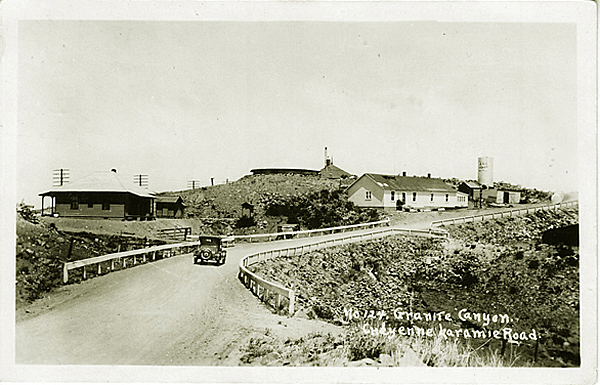
Lincoln Highway, Granite Canyon.
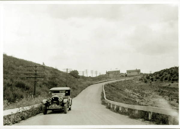
Nine miles west Cheyenne the early traveller came to Granite Canyon.
Lincoln Highway, Granite Canyon.
The 1916 Official Guide reported that Granite Canyon
had a population of 29 but No tourist accommodations. it did, however, have a railroad station and an express
company, a telephone and drinking and radiator water.
Three miles west of Granite Canyon, the early traveler came to Ozone Crossing.
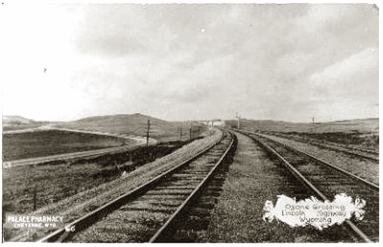
Ozone Crossing.
Sixteen miles
West of Cheyenne, one comes to a geologic formation known as the "Gangplank" where the
flat sedimentary rocks of the Great Plains are preserved along the east flank of the
Laramie Mountains. The formation permits a gradual ascent westwardly and provided
a route for the Union Pacific and later the Lincoln Highway. In the area of
Granite Canyon one enters the Sherman Mountains, actually the eroded crest of
the Laramie Range running southerly from Laramie Mountain. From the east the mountains
give the appearance of low, rounded, barren hills, notwithstanding that
they are higher than any mountains east of the Mississippi, see photo of
Tree in the Rock below.
The range includes Iron Mountain, Red Ridge, the Horse Creek Hogback, Mesa Mountain, and the
Twin Mountains. The Laramie Range consists of a pink granite estimated to be over
1.4 billion years old. The rock into which the granite was intruded is estimated to
be 1.7 billion years old. The Granite Canyon area, west of Cheyenne, was in the center of an early mining district,
the Silver Crown District, which included the Lenox Mine, the Julia Lode, the Agata Prospect and the
Arizona Mine. In nearby Hecla, was the Yellow Bird Mine.
In 1869,Albert D. Richardson, a correspondent for the New York Tribune described the
ascent from Cheyenne to Sherman:
From Cheyenne I came to Sherman, thirty-three miles west, up the first heavy
grade upon the road ninety feet to the mile. All around are bare mountain
tops. The ashen herbage is brightened by blue lungwort and yellow Arkansas
wall-fiowers, in clusters as large as the palm of a hand, or the crown of
a hat. Granite boulders of gray and brown, spotted with yellow moss, are
scattered here and there. One near the summit is fifty feet high, and
shelters the cattle of a ranchman, who has fenced in a little space beside
it.
Double snow fences of stones, or one of stones and the other of boards,
six or eight feet high and a few yards apart, follow the north side of
the track. Here and over the Laramie Plains for two hundred miles westward,
the winter is most troublesome. The Chief Engineer and Superintendent are
sanguine that after a year or two of experience they can overcome this
enemy, so that no train need ever be delayed more than twenty-four hours.
They will have to build more fences and roof the cuts, and even then they
may find their task hard. Last winter was unusually mild, but the drifts
proved very difficult to deal with.
At first, motorists along the Lincoln Highway did not have road maps to guide their way, but,
instead relied on written directions. One set of such directions prepared by a Cheyenne garage gave
instructions from Laramie to Cheyenne:
Mile 25.1 Cross road. Sherman Monument on right
Mile 25.3 Cross road
Mile 25.4 Road joins from right
Mile 26.2 Keep right hand road
Mile 30.1 Bad rock
Mile 30.4 Cross road
Mile 30.9 Buford station, cross road, keep straight ahead along RR
Mile 36.5 Bad bridge
Mile 39 Granite Canyon station, keep right up over hill
Mile 40 Cross RR track. Keep left side of track to Cheyenne.

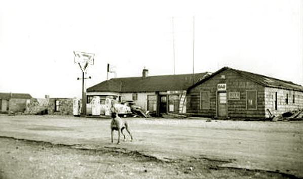
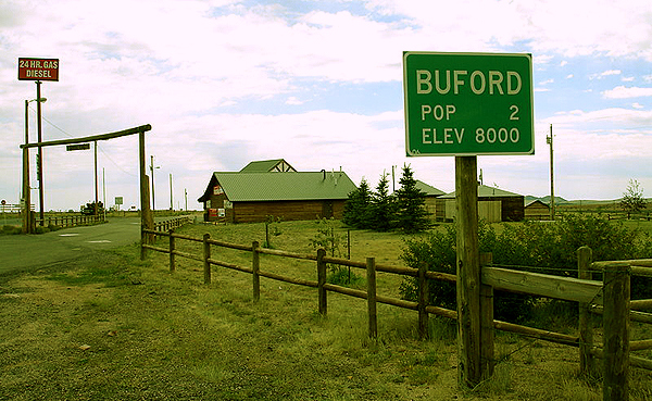
Buford Station, 1910
At one time, there actually was a station and a hotel at Buford Station.
Buford Station was at the beginning of the 20th Century a source
of "Sherman Gravel" used for railroad ballast which came from the Railroad's
own quarries. In recent years, Buford boasted a population of two, a father and son who operate the
gas station. The Official Guide reported it to have a
population of 80, but
no tourist accommodations.
there was one general
business place, 1 railroad, 1 express company, 1 telephone
company, 1 public school. Beautiful scenery.
From the telegraph station one could seen the "Twin
Mountains" two peaks in the Black Hills, near which the
noted desperado, Jack Slade, once had his retreat.
At Buford, the Lincoln Highway initially turned to the southwest toward Tie Siding and then
northward to Laramie. Soon, however, proposals for relocation of the highway to a route
from Laramie to Cheyenne either via Happy Jack Road or via Telephone Canyon began to be considered. Telephone Canyon
had the advantage of saving six miles between the two cities. The Lion's Club advocated a route which they
labeled the "Lions Trail." In 1916 the official route of the Lincoln Highway was rerouted through
Telephone Canyon. And in the debate, just as Denver attempted to divert traffic, merchants along by-passed routes were not above
misleading motorists. The kLaramie Republican, July 20, 1920, reported rumors that tourists were being misdircted away from Laramie
by a garage in Tie Siding:
It seems that the garage at Tie Siding has been instructing toursts to take the road
through Boswell's and North Park, instead of the Lincoln highway, alleging that the highway was in terrible
condition near Medicine Bow. Such rports are untrue, as the Council of Industry has ascertained that the Lincoln highway out of Medicine Bow
has been repaired and a crew is now leveling off all rough spots.
As the travel will fron now on come through Telephone canyon, it is not considered that tourists will be further misdirected.
As noted in the next photo
the population of Buford has declined but there is a business for tourists.
Buford Station approx. 1954
Subsequent to the above photo, the town burned down as a result of a
ligntning strike. It was rebuilt by its
then owner Don Sammons.
For a while it had a population of 2, but his son moved away leaving the town with a population of 1.
In 2011 it was sold.
Buford Station.
from Buford Station one could take an
alternate route to Laramie via way of Tie Siding.West of Buford Station the
early motorist came to a sight which became in many ways the symbol of the
Lincoln Highway in Wyoming, the Tree in the Rock, the Ames Monument and
the site of the town of Sherman.
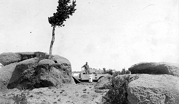
Lincoln Highway Field Secretary's official car at the Tree in the Rock, approx. 1919.
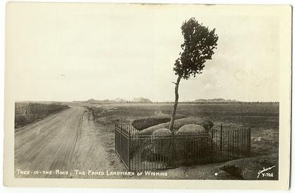 Lincoln Highway at the Tree in the Rock
In the spring of 1868 when the Union Pacific was being constructed west of Cheyenne, the surveyors came across this struggling small tree growing out of a
solid boulder of 1.43 billion year old pink Sherman granite. The railroad was relocated so as to
preserve the tree. Locomotive engineers would stop to water the tree. Lincoln Highway at the Tree in the Rock
In the spring of 1868 when the Union Pacific was being constructed west of Cheyenne, the surveyors came across this struggling small tree growing out of a
solid boulder of 1.43 billion year old pink Sherman granite. The railroad was relocated so as to
preserve the tree. Locomotive engineers would stop to water the tree.
In 1902, the railroad was relocated so as
to avoid the steep grade at Sherman Hill and the necessity of double-heading the locomotives up the grade from Laramie. The old
rail grade continued to be used as a wagon road. With the opening of the Lincon Highway, the old
grade continued along the same location. Today, I-80 continues along the same
route with the tree in a wayside park located in the median.
Music this page: Lincoln Highway, a Two Step composed in 1921 by Harry J. Linoln(1878-1937) and arranged for
Horse Creek Cowboy Band. It was a popular dance hall number in the 1920's.
Next page, Lincoln Highway, the Summit.
|