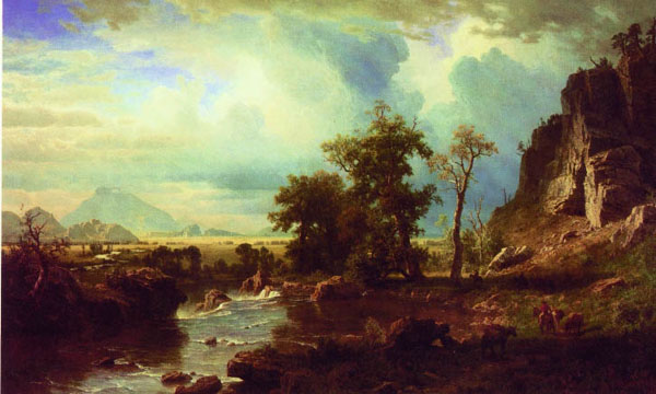
North Fork of the Platte, A. Bierstadt
As indicated in the discussion of Lander and the Wind River Basin,
Albert Beirstadt accompanied the 1859 Lander Expedition along the North Platte River and into
the Wind River Basin. Wyoming is unique that it has a triple continental divide; that is
snow falling in Wyoming may ultimately end up in the Gulf of Mexico, the Gulf of California, or the
North Pacific. Three great river systems of North America find their headwaters in the State. The Little
Missouri, Powder River, the Big Horn and the Shoshone all find their way into the
Missouri-Mississippi River System. The Snake feeds the Mighty Columbia and the Green River, changing its name to the
Colorado, ends in wet years in the Gulf of California. In dryer years it has all the water
sucked out for irrigation and to provide water for the golf courses of Las Vegas and Palm
Springs. But of the various rivers of America one of the most important from an
historical viewpoint is the North Platte. Three of the great western trails followed its
banks, the Oregon, the Mormon, and for a short distance the Cherokee. The North Platte
arises in North Park, Colorado and proceeds northward past Riverside and Saratoga. The Cherokee Trail
followed the North Platte southward from Colorado until the present location of Saratoga before it turned
westward.
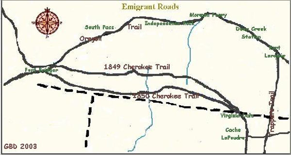
Map of Cherokee Trail and Oregon Trail
As illustrated by the map, the Cherokee Trail was actually
two trails, the Northern laid out in 1849 by Capt. Lewis Evans. Four companies from Arkansas and
Oklahoma followed the trail to Fort Bridger and then west to the California
gold fields.
From their days in North Carolina and
North Georgia, the Cherokee were familiar with placer mining of gold and, thus, as did the Whites, joined the 1849
gold rush.
The Trail proceeded from Arkansas westward to Bent's Fort, Colorado. From there the trail proceeded westward
to the Front Range where it followed the old Ute Trail from Manitou Springs northward crossing the South Platte near present day Denver.
From there it continued northward near what is now U.S. Highway 287 to near present day
Fort Collins. From there it followed the Cache LaPoudre ultimately coming to the North Platte. It then followed
the North Platte northward to the area of present day Saratoga where it crossed the
river and proceeded westward north of present day Baggs and Dixon across the Red Desert and continued on to Fort Bridger where it picked up
the California Trail.
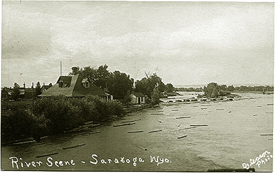
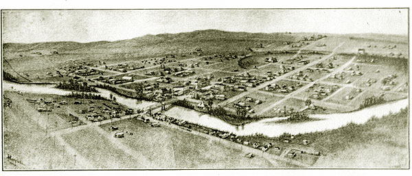
N. Platte at Saratoga, undated.
As suggested by the logs in the river, the North Platte was early important in the timber industry.
With the coming of the Union Pacific Railroad further to the north, tie hacks spread across the Midicine
Bows. In the spring with high water, the ties would be floated down the North Platte to
Fort Fred Steele. The lumber industry has until recently remained important to Saratoga. As of 2007,
the former Louisiana-Pacific lumber mill was closed. The Town has undertaken a
study on the feasibility of rejuvenating the timber industry.
The Southern Cherokee Trail established in 1850 followed the same route to
Fort Collins but turned northward at Laporte to the area of present day Tie Sidings and
then westwardly to Saratoga. Prior to the Civil War, the Cherokee Trail provided a major route from
Arkansas, East Texas, and southern Missouri to northern California. Additionally, it was used during the
Mormon War. In 1862 as discussed with regard to the
Overland Stage, Indian problems forced the Overland Stage further south and the main Emigrant's Road
along the North Platte was abandoned. The Overland Trail joined with the Cherokee
Trail at Cache LaPoudre and separated west of Tie Siding. The two trails rejoined near Fort Bridger. Thus, portions were extensively used. Indeed,
the Cherokee Trail served as a main stage road from Denver City to the
Overland Trail. Other portions of the trail in the area of the Red Desert,
particularly after the coming of the Railroad, were used primarily by adventurers, trappers and Brown's Hole outlaws such as
the Wild Bunch. A third trail
later used Bridger's Pass.
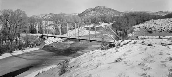
Bridge Near Riverside, Carbon County, Wyo.
Photo courtesy Library of Congress, Prints and Photographs Division
The above bridge built about 1930 replaced an
earlier timber bridge built in 1905. For additional photos of the Saratoga area, see Encampment.
Saratoga, 1903, illustration by Merritt D. Houghton.
For discussion of Houghton, see Encampment.
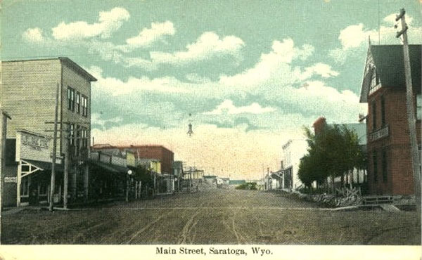
Saratoga, approx 1910
The Wolf Hotel on the left in the photo, was constructed
by Frederick G. Wolf in 1893 and opened in January 1894. Wolf was a native of Wurttemberg in
preent-day Germany and came to this country in 1869. He was a foreman for the
Union Pacific in Rawlins and came to the Saratoga area in 1887 seeking relief from
rheumatism in the warm spring. The hotel was a stop on the Walcott, Saratoga and Encampment stageline
operated by Charles M. Scribner (1841-1919). Scribner came to the valley as a wood contractor.
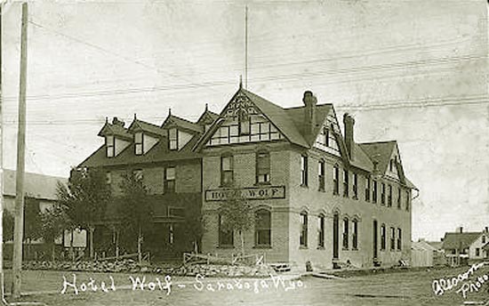
Wolf Hotel, 1909. Photo by Olin S. "O.S." Gleason.
The hotel has been restored and is still in operation. It is on the National Register. For discussion of
O. S. Gleason see Casper.
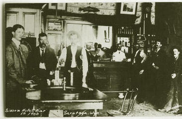
Bar in the Wolf Hotel, 1900.
The caption on the photograph is not in error. It is a reprint by William P. Sanborn of an early photograph of
the Wolf Hotel Bar. In 1919, after the photograph was taken, the hotel was sold to George W. Sisson (1866-1935) who renamed the
hotel. Sisson along with two others drowned in the Platte River near Pick Springs when their boat capsized. Subsequent owners renamed the hotel
back to its original name of Hotel Wolf. Note the roulette wheel.
As alluded to, Saratoga has a warm spring which appealed to
early trappers and tie hacks. Early settlers in the area included brothers William H. Cadwell and
Willard Cadwell. William came to the area in 1872 and proved up his homestead in 1880. Previously he been a hunter for the
Overland Stage and worked as a proospector. Others included stockbreeder
William G. Forney and John Henry Mullison (1842-1912). Mullison came to the area from Meeker, Colorado, about
1870 and worked as prospector, tie camp boss, and later as a forest ranger in the Medicine Bow National
Forest. Each are remembered in the names of local landmarks, the Cadwells in the name of
Cadwell Slough to the west of Saratoga, Forney in the name of an irrigation ditch, and Mullison in the name of
Mullison Creek and Peak in the Medicine Bows.
Saratoga as a town, however, traces its origins to the Cadwells who in 1876 built a bath house for trappers and travelers passing through the area.
In that year Henry Seton-Karr (later Sir Henry), British hunter, adventurer and later Member of Parliament, on a hunting trip guided by
Frank Earnest, brother of Boney Earnest, rode into town from hunting in the Medicine Bows and along the Little Snake. He described the little town as
"a small collection of wooden huts close by the natural warm springs that have since helped to make
Saratoga, Wyo., a thriving western town." He recalled the ride:
I shall never forget that ride. It was fine when we started, but came on to snow and blow
for the last two hours of the journey. We arrived at Saratoga half frozen, starving,
miserable, only too delighted to crowd into the shelter of a two-roomed shanty, where a
cheery settler and his wife entertained us with their best. The wife, by-the-by, was
a most beautiful young woman, obviously with a 'touch of the tar-brush' in her pedigree,
but, as sometimes happens in such cases, possessing a perfect face and figure, a wealth of
wavy dark hair, and ' velvet' eyes. It is one of the ironies of the situation that this
lovely young creature should thus unexpectedly appear in an out-of-the-way log hut on the Main
Divide, far away from the railroad and civilization, to do the honours to a weather-beaten
hunting-party seeking shelter from a November blizzard. "My Sporting Holidays," Edward Arnold, London, 1904.
In 1883, as discussed on the next page, Sir Henry purchased, among others, the Earnests' "Pick" ranch in the North Platte Valley.
Subsequently, as depicted below, the Cadwells constructed a "first class" hotel adjacent to the springs.
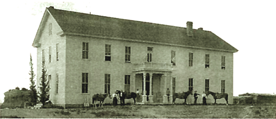
W. H. Cadwell's Saratoga Hot Springs Hotel, 1884.
The hotel had 28 guest rooms. Among the guests who stayed at the hotel was William Jennings Bryan. Cadwell advertised the springs
as containing iron, potasium, lime, magnesia, chloride of sodium and sulphur. He claimed that the
waters were a "POSITIVE CURE for all diseases aring from an Impure state of the Blood -- A certain specific for
RHEUMATISM." The hotel burned down in 1902 from a fire starting in the ladies lounging room of the adjacent two-story bathhouse. The wind blew the flames from the
bathhouse over into the hotel.
The only guests injured in escaping the fire were the Revenend
Henry E. Brundage and E. G. Ashey each of whom had to shinny down the columns supporting the front porch of the hotel. Each had their hair singed. The Reverend
Brundage had been in the attic rescuing his sermons which he stored there. Mrs. B. C. Fay's dignity was injured in fleeing from the
burning bathhouse where she was bathing. According to the
Saratoga Sun, she "barely" escaped "without any clothing whatever." At the time of the fire, the hotel was owned by
Fenimore Chatterton. In 1921, the State purchased the Springs for $50,000.
In 1878, a post office had been established with the name "Warm Springs." This, however, was changed
to Saratoga after Saratoga Springs, New York by Chatterton (1860-1958) who operated a
general store. Chatterton previous had served as the manager of the J. W. Hugus store at Fort Fred Steele down river from Saratoga.
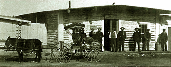
J. W. Hugus Store, 1877.
Hugus (1834-1901) was the post trader at Ft. Steele from 1870 to 1883. Prior to coming to Ft. Steele, Hugus had been
post trader at Fort Kearney, Nebraska. Before the Civil War Hugus had been a printer and typesetter in various places across the West.
Beginning in 1880 Hugus began expanding his merchantile business establishing stores in
Rawlins, Saratoga, Wamsutter, and various locations throughout northern Colorado and eastern Utah.
His chain of stores ultimately grew to some 12 stores. He also served as president of the First National Bank of Rawlins and the
Bank of Saratoga.
In 1883, Hugus moved to Pasadena, California, where he maintained a ranch and also was in the banking business. The mercantile business remained, however,
headquartered in Rawlins managed by John C. Davis. The store in Saratoga was sold to Hugas' brother, Wilbur Belden "W. B." Hugus.
W.B. had previously served as a post trader in Arizona during General Crook's campaigns there. W. B. Hugus was
president of the the Saratoga Real estate and Improvement Company. John W. Wood, an owner of the Pasadena and Valley
Union newspaper later wrote of an encounter with J. W. Hugus at
a time
when the paper was first stated:
One of the interesting incidents connected with the early establishment of the Union,
I will relate with pleasure; a tribute let it be to the good heart and modesty of a man
now gathered to his fathers. One day, when all were busily engaged in arranging the new
office, there appeared an elderly gentleman of agreeable mien, who said he used to be a
printer in the long ago, and "could he help a little, so as to 'get his hand in' again,
could he assist us 'laying' (distributing) type?" He was informed that his services would
be acceptable, as we were in much hurry. Quietly he hung up his coat on a nail behind the
door, and proceeded to get busy. Industriously he worked, every day, for a week; saying little,
whistling now and then a bar or two of an old time air. No one asked him who he was or whence
he had come, for the "tramp printer" was more common then than in the present day of the
linotype.
The type had been distributed, the office was "in form" at last, and the stranger,
seeing the finish, one evening took down his coat from its nail, and prepared to depart.
The proprietors were loath to see him go, so well had he labored, so quiet and
unostentatiously had he performed his share; but there was no need of the "extra" now,
and he was requested to name the sum due him for his work. I yet see the whimsical smile
upon that face as he said, "Well, brother, you don't owe me one cent." "Don't owe you a cent?"
said the astonished editor, "how is that? You've worked a whole week." "Well, you see,"
responded the other, "I liked that job first rate, and just wanted to know whether I'd lost
my old knack of it. I'm John W. Hugus, and I live down on Moline Avenue, and I'm mighty glad
to give you a helping hand!" The editor was taken aback, for this John W. Hugus was the wealthiest man then
in Pasadena, having not long before arrived and established his home. It was a good joke in that
sanctum, and long remembered with enjoyment. John Hugus has marked "30" long ago, but for years
was one of Pasadena's well known figures.
Writer's note: "30" in telegraphic terminology was a code for "end of message." It was also the number of
standard pica em slugs that could be cast in a single line on an old-fashioned "hot metal" typesetting machine. At the
end of an article or story, an old-time typesetter would place a 30 slug denoting where he left off.
In the last few years of his life, Hugus donated about $300,000 (in 1902 dollars) to educational and Episcopal Church
purposes in Wyoming, California, and Colorado. He died while attending
an Episcopal conclave in Los Angeles. Today, he is remembered in Pasadena by a wall marker placed in a alley off
Colorado Blvd. In Saratoga, there is a restuarant on North Front Street named for him. W. B. Hugus died in July, 1909, a resident
of Santa Cruz, California.
Later, Chatterton was
Secretary of State and upon the death of Governor DeForest Richards became acting Governor.
Chatterton refused commutation of Tom Horn's death sentence and failed of election in 1905 and
was succeeded by Bryant B. Brooks. Saratoga was incorporated in 1900.
Next page: Saratoga photos continued.
|