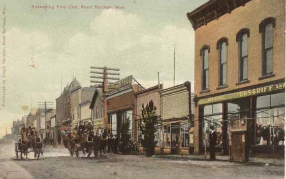
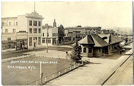
Fire Brigade, Rock Springs, Approx. 1900
The above scene is directly in front of the Union Pacific Depot on South Front Street, see next photo.
The Cosgriff Store, on the right in the picture, was one of a chain of stores operated
by the Cosgriff Brothers, T. A. Cosgriff, John Cosgriff, and James Cosgriff, of Rawlins. The Cosgriffs
also owned a number of banks and at one time had as many as 125,000 sheep. Note false fronts on the second, third and fourth
buildings from the right. The fourth building, with the sign braced on the
top of facade, is
J.P. McDermott Co., a grocery. Past the building with the gable is the Pacific Market.
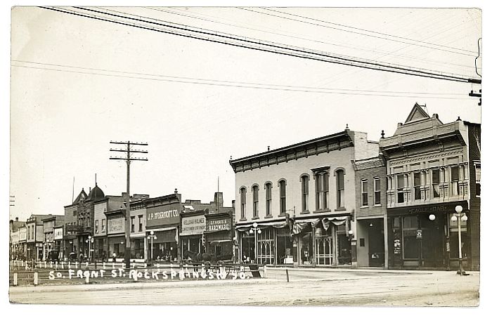
South Front Street, approx. 1915.
Rock Springs originally was merely a way station on Ben Holladay's Overland Stage Line
after the line was moved south in 1862 to avoid Indians. The stage station was located about
3/4th of a mile north of town on the west side of Killpecker Creek adjacent to springs which emerged from
chalk cliffs.
There is some speculation as to the origin of the name "Killpecker Creek." It is generally believed that the name
originated with soldiers as relating to the water's effect on the body. See Urbanek, Mae:
Wyoming Place Names, Mountain Press, Missoula, 1988, p. 113. See also, Randolph, Vance: Unprintable Ozark Folksongs and Folklore,
Krypatadia, Inc., 1992, p. 712. One of the first station attendants, Archie Blair, however,
referred to the creek as "Kilpatrick Creek." See Paterson, infra. Rhyming substitution is not limited
to the Cockney Tribe in Britain. Thus, the name may merely be a ribald substituion for a more posaic name or, alternatively,
a prosaic substitution by Blair for a ribald name much in the same as "Warhouse Creek" in
Park County has replaced a more suggestive name.
As noted, the first station attendants were Scotish prospectors, Archibald "Archie" Blair and his
brother, Duncan Blair. The bothers having unsuccessfully prospected in California, came to what was to become Wyoming
intending to prospect in the Jackson's Hole area.
The station was described as:
[Of] stone, with a roof of logs and brush, overlaid with sand
and earth. It. was sixty feet long by twenty-five wide. Every twelve feet marked a port
hole in the side walls, while on either side the great door and the fireplace was the
same provision for defence in case of attack by Indians or bandits.
The great door faced the south, and not far beyond stood the corral. Within the great
door were six stalls for horses, always harnessed and ready for the incoming coach.
There was a granary for supplies, and then the large room with the huge fireplace.
Paterson, Mary A.: The Old Stage Station at Rock Springs, Proceedings and Collections of the
Wyoming Historical Department, 1919-1920, p. 121
In 1866, the Blair Brothers constructed a store and a bridge across the creek. The following year,
they began a coal mine two miles south of Rock Springs at what was to become known as "Blairtown."
As a town, Rock Springs received its start in 1868 when the Railroad arrived. The mining rights were then leased out to the Union Pacific Coal Company.
Because of the Union Pacific's control over transportation costs, the brothers were unable to compete and, instead,
devoted their interests to stockraising. Archie ran the Circle Ranch, twenty miles south of Rock Springs and
Duncan the "B B" ranch. Both brothers served in the territorial legislature and after statehood Archie served in the
state legislature.
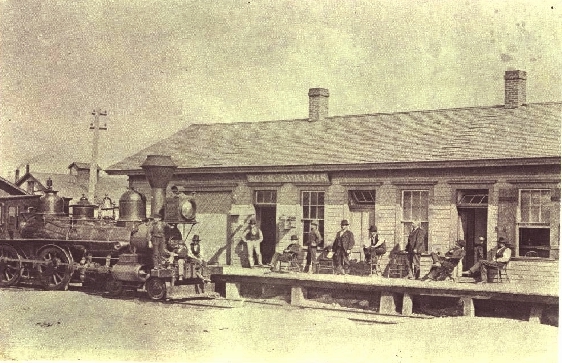
Rock Springs Station, approx. 1870
Prior to the coming of the Railroad, the Bitter Creek Valley, of which Rock Springs is a part, was not regarded as very
hospitable. John Hanson Beadle, in his 1873 The Undevloped West, or, Five Years in the Territories,
described the area:
"For sixty miles on Bitter Creek, Wyoming, the soil is a mass of clay
or sand and alkali--a horrible and irreclaimable desert, which has made
the place a byword. For a few days our average elevation was 7000 feet
above sea-level and the nights were extremely cold. On the 22d we reached
Bridger's Pass, and next day entered on the Bitter Creek region--horror
of overland teamsters--where all possible ills of western travel are
united. At daybreak we rose, stiff with cold, to catch the only temperate
hour there was for driving; but by nine A.M. the heat was most exhausting.
The road was worked up into a bed of blinding white dust by the laborers
on the railroad grade, and a gray mist of ash and earthy powder hung over
the valley, which obscured the sun but did not lessen its heat. At
intervals the 'Twenty-mile Desert,' the 'Red-sand Desert' and the
'White Desert' crossed our way, presenting beds of sand and soda, through
which the half-choked men and animals toiled and struggled, in a dry air
and under a scorching sun.
"In vain the yells and curses of the teamsters doubled and redoubled,
blasphemies that one might expect to inspire a mule with diabolical
strength; in vain the fearful 'blacksnake' curled and popped over the
animals' backs, sometimes gashing the skin, and sometimes raising welts
the size of one's finger. For a few rods they would struggle on, dragging
the heavy load through the clogging banks, and then stop, exhausted,
sinking to their knees in the hot and ashy heaps. Then two of us would
unite our teams and, with the help of all the rest, drag through to the
next solid piece of ground, where for a few hundred yards the wind had
removed the loose sand and soda and left bare the flinty and gravelly
subsoil. Thus, by most exhausting labor, we accomplished ten or twelve
miles a day. Half an hour or more of temperate coolness then gave us
respite till soon after sundown, when the cold wind came down, as if in
heavy volume, from the Snowy Range, and tropic heat was succeeded by
arctic cold with amazing suddenness. On the 27th of August one of my
mules fell twice, exhausted from the heat; that night ice formed in our
buckets as thick as a pane of glass."
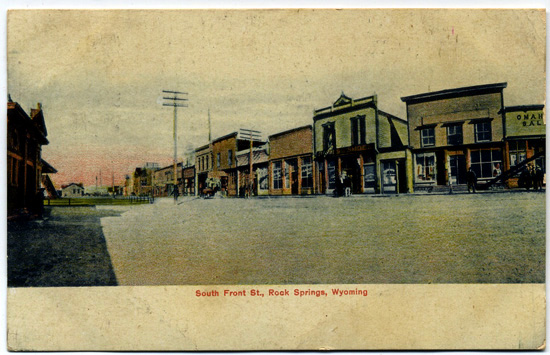
South Front Street, 1908.
The above scene is further down the street from the upper views.
The town was described in a letter dated 1876 written by Mabel Hubbard to her future husband Alexander Graham Bell:
We are stopping now at a coal station, and have come upon the first signs of life
except the miserable little house that adjoins the wood stations. There are
coal mines around, on the hills on my left I see smoke rising out from the hills,
it is a mine or fire, nearer us smoke rises from some tall chimneys of
manufacturing buildings, we have come to the first busy looking place
for many a long mile but the houses are all of the poorest description
and look temporary. There is no appearance of home about them as there
was in even cold and dreary Lamarie. There the land is cultivable and
settlers have made homes there, here the fetid water's make mans stay here
one of necessity never of choice.
O how I wish you were here you would enjoy it all so much, the wild
scene -- not the living!!. Our party is reduced to it's usual size
again except for the presence of Dr. -- Superintendent of Mints of the
United States.
When you write to your Mother please give her my love and tell her I
want to write to her but cannot do so very well in the cars.
The houses of the miners are built in an abrupt ravine, the walls
of which form one of the sides of their houses. The roofs and sometimes
a window project above the surface of the ground -- the roofs are covered
with dried earth and clay, and the whole settlement has such a queer
appearance. Just now a "heaten Chinee" passed us trudging laboriously
along with a big piece of raw meat at one end of a long branch he carries
over his shoulder and a heavy sack on the other end. We have come to the
region of chinamen. The valley around us is so queer flat with sudden
fissures running through it. The ground is covered with bunches of the
sagebush. Just now a pure white mountain rises up over the rock hills
around us, sharp and white against the blue sky recalling the Jung'frau
in it's shape and sharp stern purity. Rock Creek is the name of the mining
station we have left, hills near us grow more and more peculiar in their
formation at their base are rounded pillar-like protuberances.
[Writer's note:
It appears likely that Miss Hubbard miswrote. The letter was written in a
palace car on the Union Pacific heading west between Bitter Creek and Salt Lake. The letter indicated that
the quoted portion was written before reaching Green River. Rock Creek is in Albany County some
distance east of Bitter Creek in Sweetwater County. Additionally, the railroad
did not reach Rock Creek until 1878, two years following the letter.]
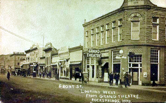
North Front Street, 1915
The building on the corner is the Labor Temple and bears the date
1914 on the pediment.
Front Street, 1919.
Next Page: Rock Springs Coal Mines
|